


 Author:

The Vail Mountains are truly a mecca for outdoor adventure and exploration. While Vail is best known as a winter ski and snowboarding destination, the epic adventures continue all year long throughout Vail’s various incredible hiking trails.
From short, easy hikes with gorgeous views to long, challenging treks with epic mountain vistas and views of alpine lakes, Vail has a hike for everyone.
Whether you’re a beginner seeking a leisurely stroll in nature or you’re a veteran hiker looking for your next incredible journey, this beautiful area has no shortage of amazing hikes.
Let’s jump right into the best hikes in and around Vail, Colorado!
1. Booth Falls

- Difficulty Level: Moderate
- Distance: 4.2 miles
- Elevation Gain: 1,358 feet
- Best Season: May to October
- Pet Friendly: Yes
The Booth Falls Trail is a beautiful hike in East Vail that takes you right along the riverbanks of Booth Creek up to the incredible 60-foot Booth Falls.
Backpacking to the falls, you’ll see beautiful meadows and alpine forests and have ample opportunities to spot wildlife. Many hikers report seeing big horn sheep and many different bird species. hike a bit further, and you’ll encounter the pristine Booth Lake.
Booth Falls is a great hike any time of year, but it really shines during the fall foliage. Between late September and early October, the Aspen trees exchange their summer green for leaves in stunning shades of gold, red, and orange, and the views of the colorful aspen groves from the trail are incredible.
While most prefer this hike during the summer and fall months, the hike to Booth Creek Falls is also great in winter! Depending on the conditions, you can snowshoe or hike the trail with crampons.
How To Get There
To get to the Booth Falls Trailhead, you can park or walk to Vail Village and take the free shuttle bus, which is just a 5-minute drive from there.
2. Shrine Ridge Trail

- Difficulty Level: Moderate
- Distance: 4.3 miles
- Elevation Gain: 1,030 feet
- Best Season: June to October
- Pet Friendly: Yes
Located just off Vail Pass, the Shrine Ridge Trail on Copper Mountain is ideal for mountain biking and hiking. Just thirty minutes from the Vail Ski Resort, this trail takes you through pine meadows full of wildflowers, ponds, and pine forests until you get to the top of Shrine Mountain.
From the top, you’ll have incredible views of the neighboring mountains and a great view of the famous Mount Holy Cross- a majestic mountain with a natural, snowy cross etched into it.
In addition to the views from the top, one of the best parts of this hiking trail is all of the wildflowers! The lush, green meadows contrast incredibly with the bright hues of the Indian paintbrush and lupine. If you want to experience the wildflowers in their peak glory, July is the ideal time to visit.
How To Get There
To get to the Shrine Ridge Trailhead, you’ll take the I-70 E and exit at Vail Pass exit #190. You’ll then follow Shrine Pass road for about 2.3 miles until you get to the dirt parking lot for the trailhead. Due to the heavy snow and weather conditions on Shrine Pass Road, this trail closes seasonally from November-May.
3. Strawberry Lane
- Difficulty Level: Easy to Moderate
- Distance: 2.7 miles
- Elevation Gain: 682 feet
- Best Season: May to October
- Pet Friendly: Yes
Strawberry Lane is a fun, easy-to-moderate level hike out of Vail Village. While the trail is only 2.7 miles, the first half consists of a fairly steep uphill section that leaves many hikers feeling quite winded. However, the views on the Strawberry Lane Trail are worth the rapid ascent.
You’ll cross lovely streams and fields of wildflowers along the way while listening to birds and watching chipmunks dart across the trail. This hike is most popular in the summer to see the wildflowers and in the fall to experience the foliage, and it is closed during the ski season.
Additionally, the trail is very shaded, which makes it one of the more comfortable Vail hiking trails when it’s particularly hot out. It’s a great hike for families, new hikers, and anyone looking for a fun hike with wonderful views without having to stray too far off the beaten path.
How To Get There
To get to the trailhead, you can easily walk about 20 minutes from the Vail Town Center to the Vail Village gondola one base and begin your ascent.
4. Gore Creek Path
- Difficulty Level: Easy
- Distance: 1.8 miles
- Elevation Gain: 209 feet
- Best Season: May to October
- Pet Friendly: Yes
This picturesque hike is popular amongst hikers, bikers, runners, and dog walkers. The Gore Creek Path has lovely views of the surrounding forest and peaceful creek; it’s not difficult to see why this hike is so popular.
The trail is very easy and a great Vail hiking trail to do all year long. In the summer, you can hike along the creek and enjoy the shade of the trees, and in the winter, you can snowshoe your way through this lovely area.
Gore Creek Path is very easy and a wonderful option for anyone looking to dip their toes into the Vail hiking scene. If you get to the trail’s end and are craving a bit more adventure, you can always continue onto the Gore Creek Trail, which goes for a lengthy 19 miles but feel free to turn around anytime if you’re just looking to add onto the path.
How To Get There
One of the best aspects of this hike is that it is very easy to reach from Downtown Vail. You’ll simply drive down South Frontage Road West for about 2 miles and then turn left at Donovan Park for the trailhead. If you’re staying in town in a hotel nearby, you can also easily walk along to the trailhead.
5. Pitkin Lake Trail
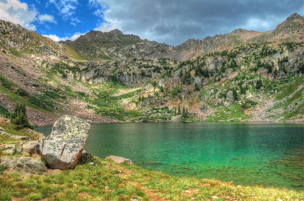
- Difficulty Level: Hard
- Distance: 10.5 miles
- Elevation Gain: 2,975 feet
- Best Season: June to October
- Pet Friendly: Yes
If you’re seeking a challenging hike with breathtaking views without having to venture too far from Vail, the Pitkin Lake Trail is for you.
This hiking trail is rated difficult and clocks a staggering 2,975 feet of elevation gain throughout the 10.5-mile hike. However, the views are something you’ll never forget and are well worth the effort.
As you hike to Pitkin Lake, you’ll venture into the Eagles Nest Wilderness area. You’ll hike along creeks and through dense alpine forests. The trail also offers up incredible views of the Gore Mountain range.
You’ll pass not just one but two incredible waterfalls, all on the way to Pitkin Lake itself. Pitkin Lake is incredible- it’s a serene, alpine lake surrounded by granite walls dotted with pine trees. While the first part of the hike is steep, the incline is gradual for most of the way, and it’s a very enjoyable hike to do between June and October.
How To Get There
The Pitkin Lake Trailhead is easy to reach from Vail. You’ll simply hop on the I-70 East, take exit #180 for Vail, turn left onto Big Horn Rd, and then right onto Fall Line Dr, and the trailhead is on your left.
6. Berrypicker Trail
- Difficulty Level: Moderate to Hard
- Distance: 7.9 miles
- Elevation Gain: 2,286 feet
- Best Season: All Year
- Pet Friendly: Yes
The Berrypicker Trail out of Lionshead Village is a challenging yet rewarding hike. an incredibly steep, 7.9-mile out & back trail, and it’s one of the best Vail hiking trails.
As you enter into the Eagles Nest Wilderness area, you’ll be surrounded by graceful aspen trees, and you’ll wind through meadows and receive panoramic views of both the quaint mountain town of Vail and surrounding mountain peaks.
The Berrypicker Trail is also a great place to spot wildlife, including deer, birds, and various types of wildflowers. If you visit during foliage season, you’ll be hiking in the golden glow of the aspens.
Be forewarned; this trail is very steep and not for the faint of heart. With that said, you can always take the gondola up to the top and hike back down if you want the views and experience without the strenuous uphill part of the hike. Or, if you’re looking to make shorter work of the trail but still get a good workout in, you can hike up and take the gondola back down.
How To Get There
The Berrypicker Trailhead is easy to find, as it kicks off right above the base of the Lionshead Gondola.
7. Davos Trail
- Difficulty Level: Moderate
- Distance: 5.4 miles
- Elevation Gain: 833 feet
- Best Season: Winter
- Pet Friendly: Yes
Just outside of Eagle-Vail, the Davos Trail is one of the most popular hikes around vail and is a must-visit for any hiking enthusiasts in the Vail area.
This popular hiking trail winds through lush alpine forests and meadows full of wildflowers and delivers spectacular views of majestic mountain peaks. With an elevation gain of only 833 feet spread throughout the trail, Davos Trail is a great moderate hike for anyone struggling with the rapid elevation gains on some of these other Vail hiking trails.
The Davos hiking trail follows a dirt road service trail and is great for trekking all year long. At the top of the Davos Trail, you’ll have spectacular views of the surrounding forested hillsides, with the mountain peaks cropping up in the background.
This is one of those special Vail hiking trails that particularly shine in the winter. In the winter months, the Davos Trail becomes blanketed in snow and is incredibly peaceful and serene. It’s a great escape from the hustle of everyday life without having to venture too far from Vail itself.
If attempting this hike in the winter, you’ll want to come prepared- plenty of warm snow gear, water, and you’ll need spikes for your hiking boots. In the summer months, be sure to bring plenty of bug spray, as the trail does get quite buggy in the summer.
It’s important to note the Davos Trail does close for part of the year. Elk season occurs from April to July, and during part of that time, the Davos Trail is closed to protect the herds. You can double-check closures on the US Forest Service website.
How To Get There
The Davos Trailhead is very easy to get to from Vail. You’ll simply hop on the I-70 W for about 2.5 miles, get off at exit 173 for Chamonix Rd, turn onto Cortina Lane for about a mile, and you’ll arrive at the trailhead.
Enjoy Hiking Vail’s Finest Trails
These seven Vail hiking trails are our favorites thanks to their incredible scenery, an abundance of wildlife, and close proximity to the downtown area.
Hiking is a wonderful way to experience the natural beauty of this pristine mountain town. With dozens of great hiking trails in and around Vail, it’s not difficult to find a great trail and explore the breathtaking scenery of Colorado.
Featured Image Credit: JGA