


 Author:

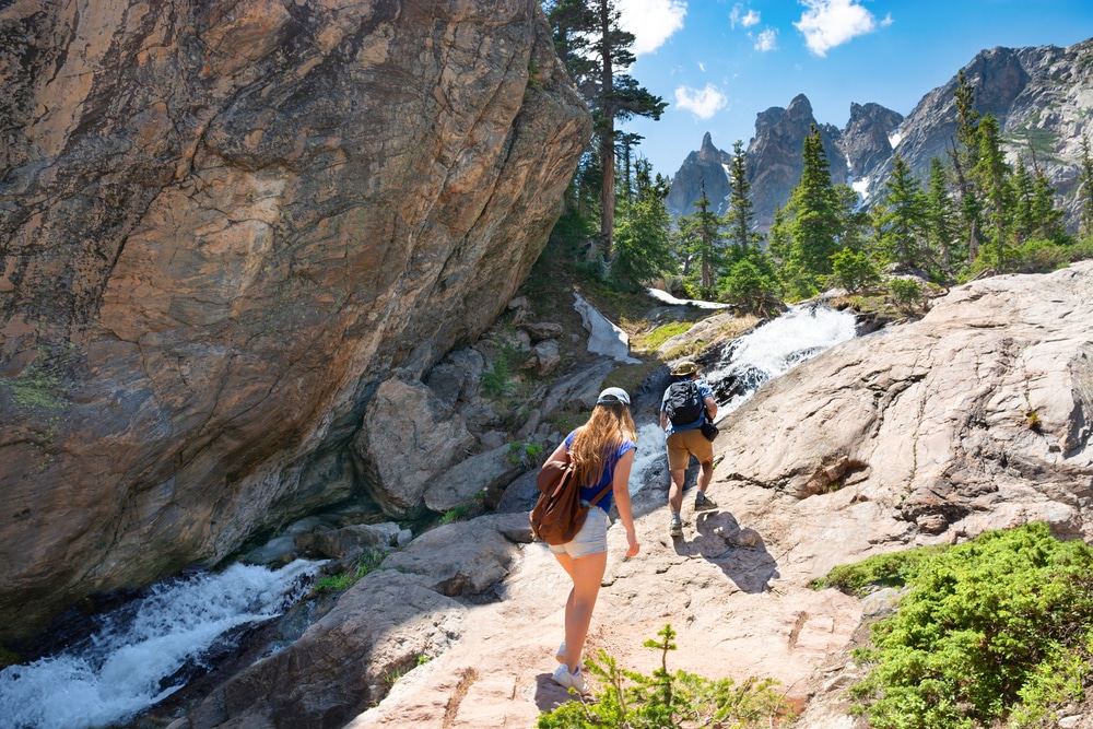
Colorado is a truly breathtaking state. It’s full of alpine lakes, majestic mountains, dense forests, waterfalls, meadows, and more! Combine all that natural beauty with the Rocky Mountains, and Colorado is truly a hiker’s paradise.
Given that Colorado has over 5,000 miles worth of hiking trails, it can be a bit daunting if you don’t know where to start. Full of national parks and state parks, you’ll have your pick of the litter when it comes to great outdoor activities in Colorado. That’s why we’ve rounded up the best hiking trails in Colorado and organized them by location, so you can have a little inspiration on where to hike.
While many of these trails aren’t open year round, they’re really enjoyable in the spring, summer, and fall. In the winter, some of them turn into ski slopes, so while you can’t enjoy them on foot, you can enjoy them on skis.
Whether you’re looking for short, easy nature walks or more vigorous hiking adventures, there’s bound to be a hike for you in this adventurer’s guide to hiking in Colorado.
Hiking Trails in Aspen
While Aspen may be best known for its skiing and snowboarding, this lovely mountain town is also home to a wealth of incredible Colorado hiking trails.
The Grottos Trail
- Length: .6 miles
- Elevation Gain: 29 feet
- Difficulty: Easy
- Trail Type: Loop
The Grottos Trail is a short and scenic hiking trail just outside of Aspen. Along the trail, you’ll see a variety of interesting water features.
One of the most unique things you’ll see on the trail is the ice caves! If you dare, you can climb down and walk through them, and marvel at the peculiar formations on the wall. However, keep an eye out for any flood warnings, as climbing down into slot canyons like the ice caves can be extremely dangerous if it’s raining heavily, or if there are any flood warnings in the area.
Along the trail, you’ll also see the cascades! These small, lovely waterfalls dump right into the river below where you can dip your toes in the icy water to cool off.
The Grottos Trail is perfect for anyone looking for a short, easy hike outside of Aspen where you can still admire plenty of nature. This trail is very popular though, and it’s a good idea to get to the trailhead by 7 am if you want to guarantee a parking spot and have the trail to yourself.
Maroon Bells Scenic Trail

- Length: 1.9 mile loop
- Elevation Gain: 160 feet
- Difficulty: Easy
- Trail Type: Loop
The Maroon Bells Scenic Loop Trail is located in White River National Forest, in the Maroon Bells-Snowmass Wilderness Area, about 25 miles from Aspen.
This relatively short and easy hike will take you all around Maroon Lake, giving you fantastic views of the lake itself and the surrounding meadow. You’ll also be privy to some absolutely incredible views of the mountain peaks beyond the lake.
If you’re looking for a short and easy hike that still has incredible views, you can’t go wrong with the Maroon Bells Scenic Trail. If you enjoy the park as much as I did, there are several longer backpacking trails in the area as well.
It’s important to note you’d like to do this hike, you will need a reservation as of 2021, and can inquire about this with the Forest Service.
Hanging Lake Trail

- Length: 3.1 miles
- Elevation Gain: 1,187 feet
- Difficulty: Moderate-Hard
- Trail Type: Out & Back
The Hanging Lake Trail is technically in Glenwood Springs, about 1 hour away from Aspen. However, since this is one of the most beautiful trails in all of Colorado, it had to be included on this list! Plus, since it’s in Glenwood Springs, you can relax in one of the area’s hot springs to relax your muscles after the hike.
The Hanging Lake Trail meanders along a creek all the way up to the Hanging Lake. The Hanging Lake gets its name due to a geological fault that pushed the lake bed away from the valley floor.
This geological wonder is even more magical due to the lake’s vivid blueish-green hues that come from mineral deposits. While the trail itself takes about 2 hours to complete, you’ll want to allow yourself much more time here to enjoy the lake.
A permit is required for this popular hike, and you can find one here!
Cathedral Lake Trail
- Length: 5.4 miles
- Elevation Gain: 2,070 feet
- Difficulty: Hard
- Trail Type: Out & Back
The Cathedral Lake Trail is one of the most stunning Colorado trails. This 5.4 mile hiking trail is rated as difficult, and with 2,070 feet of elevation gain, it’s no surprise as to why.
However, the ascent is well worth the effort! This trail offers breathtaking views of blue lakes, wildflowers, rocky mountain sides, and you can even swim in the lake!
The trail terrain is fairly rocky and steep, so you’ll want hiking shoes with good traction. To reach the lake, you’ll also have to do a creek crossing, so you’ll want shoes that are waterproof, or that you don’t mind getting wet.
Hiking Trails in Boulder
Home to lush pine forests, The Flatirons, and some incredible rock formations, it’s no surprise that hiking in Boulder, Colorado is so great. Whether you’re looking for a simple loop trail or a more challenging ascent, you’ll be more than satisfied with the hikes in Boulder.
Wonderland Lake Loop Trail
- Length: 1.8 miles
- Elevation Gain: 88 feet
- Difficulty: Easy
- Trail Type: Loop
Wonderland Lake is conveniently located right in North Boulder. This easy, popular trail takes you on a loop right around the lake, and is perfect for hiking, biking, and running. You’ll likely spot wildflowers, and it’s a great area for bird-watching! You’ll also get a great view of the Flatiron.
If you’re looking for a fun and easy trail to get out in nature without going too far from Boulder, the Wonderland Lake Loop Trail is the Colorado hike for you. Just be sure to bring a hat and some sunscreen, as this trail has very little shade.
First and Second Flatirons Loop

- Length: 2.7 miles
- Elevation Gain: 1,427 feet
- Difficulty: Moderate- Hard
- Trail Type: Loop
First and Second Flatirons Loop trail is one of the best hikes in the Boulder area. From the base to the summit, the trail maintains incredible views of The Flatirons.
This hike isn’t for the faint of heart though- even though it’s not a very long hike, the ascent is very steep and can be brutal at times. You’ll have to do a bit of scrambling over rocks to get to the top, which is great fun for a seasoned hiker, but a little less than ideal for beginners, or those with dogs.
You’ll pass by impressive sandstone slabs, forests of pine trees, and even grasslands on this adventurous Colorado hike. This trail is popular with hikers and climbers alike, and often gets crowded. If you can’t find parking at the trailhead, you can park along Baseline Road.
Royal Arch Trail

- Length: 3.1 miles
- Elevation Gain: 1,394 feet
- Difficulty: Hard
- Trail Type: Out & Back
This 3.1 mile hike kicks off at the Chautauqua Park Trailhead. After passing through an access road, you’ll enter a beautiful pine forest. Within the forest, you’ll begin a steep ascent that includes a flagstone staircase on the way up to Sentinel Pass.
The Royal Arch at the top is an impressive geological feature, and you’ll also be treated to a scenic vista at the top of the surrounding forest and Flatirons.
Rattlesnake Gulch

- Length: 3.6 miles
- Elevation Gain: 951 feet
- Difficulty: Moderate
- Trail Type: Loop
Rattlesnake Gulch is a moderately difficult hike that will take you through some of the most scenic parts of Eldorado Canyon. The first part of this hike has some swift elevation gain, but the majority of the hike climbs nicely and gradually.
Along the trail, you’ll pass by the remnants of the historic Crag Hotel that burned down over 100 years ago. After investigating the ruins of the hotel, you’ll continue on the trail and get to the Continental Divide Overlook. The view here of the distant mountain peaks and the overall vastness of Eldorado Canyon is absolutely incredible, and well worth the effort.
Hiking Trails in Colorado Springs
If you’re looking to escape the hustle and bustle of Denver, you can slip into the mountains right next to Colorado Springs for a variety of fun, short, and strenuous hikes, where you’ll find unique rock formations, waterfalls, and more.
Perkins Central Garden Trail
- Length: 1.1 miles
- Elevation Gain: 88 feet
- Difficulty: Easy
- Trail Type: Loop
Perkins Central Garden Trail is a fully paved and wheelchair-accessible hiking loop. On this fun and easy loop, you’ll pass by some impressive rock formations such as White Rock and Kissing Camels. This trail is also great for wildlife viewing! It’s quite common to spot animals like deer, rabbits, and plenty of birds.
If you’re looking for a fun, easy, and accessible hike where you can see many of the best rock formations in the Garden of the Gods Park, you’ll enjoy this trail. Since this trail is so popular, your best bet to beat the crowds and guarantee parking is to get there right at 8 am.
This trail is also dog-friendly, they just need to be on a leash.
Helen Hunt Falls Loop
- Length: 2.3 miles
- Elevation Gain: 413 feet
- Difficulty: Easy
- Trail Type: Loop or Out & Back
Helen Hunt Falls is a 35-foot waterfall in North Cheyenne Canyon Park. This hike begins at the North Cheyenne Canyon Road trailhead. You’ll then connect to the Columbine Trail, which will take you through a lovely pine forest and walls of granite.
You’ll be treated to incredible mountain views and a view of the valley below. You’ll finally make a left onto North Cheyenne Canyon Road, and follow that up to the waterfall.
To get back to the trailhead, the loop has you follow North Cheyenne Canyon Road back down. However, to avoid walking on the main road you can always just retrace your steps and turn this into an out & back hike. Since the signage can be a little confusing for this hike, it’s recommended to bring a GPS or a little map along to ensure you make it to the falls without any unwanted detours.
Also, if you’re keen on seeing the Helen Hunt Falls without making the 2.3 mile hike, there is a waterfall parking area off North Cheyenne Canyon Road where you can park and only walk .1 miles to the waterfall.
Mount Muscoco Trail
- Length: 4 miles
- Elevation Gain: 1,292 feet
- Difficulty: Moderate
- Trail Type: Out & Back
This fun 4 mile trail steadily climbs up Mount Muscoco. The last ¼ mile of the hike is quite steep and has some loose rocks and gravel that can be challenging but doable with proper hiking boots. Aside from the last part, this hike is only moderately challenging.
The 360 views from the top are incredible. You can see almost all of Colorado Springs in one direction, and in the other, you’ll spy more of the Front Range mountains. You can also spy the canyon below, and if you’re lucky, you’ll catch a glimpse of one of the Seven Falls.
St. Mary’s Falls Trail
- Length: 5.9 miles
- Elevation Gain: 1,394 feet
- Difficulty: Moderate
- Trail Type: Out & Back
St. Mary’s Falls Trail is a moderately difficult hike located just outside of Colorado Springs, in North Cheyenne Canyon Park.
This trail is quite popular amongst hikers, horseback riders, and mountain bikers, and it’s no secret why. On this 5.9 mile hike, you’ll enjoy the scenery of massive evergreens, lovely little creeks, and two waterfalls, including the thundering, 300-foot St. Mary’s Falls.
Since this area gets pretty hot and dry in the summer, it’s best to go in the springtime if you want to see the waterfall at its full potential.
If you’re looking for a challenging yet fun waterfall hike in Colorado Springs, this hike is a great way to spend half a day hiking in Colorado.
Hiking Trails in Rocky Mountain National Park
From snow-capped peaks, gorgeous turquoise lakes, and towering pine trees- Rocky Mountain National Park has no shortage of beauty!
This park holds some of the greatest treasures when it comes to Colorado hiking, and we’ve rounded up 4 of the best for you right here.
Keep in mind since these trails are all located inside the National Park, dogs are not allowed and you’ll need to pay an entrance fee to enter the park.
Bear Lake Nature Trail

- Length: .6 miles
- Elevation Gain: 20 feet
- Difficulty: Easy
- Trail Type: Loop
If you’re searching for a fun, flat hike that still delivers breathtaking views- look no further than Bear Lake Nature Trail. This hike is only .6 miles, and has gorgeous views of the lake, surrounding mountains, and forests.
The trail is also very informative- it has about 30 markers along the way that share bits of information about the Bear Lake area.
Alberta Falls
- Length: 1.7 miles
- Elevation Gain: 232 feet
- Difficulty: Easy
- Trail Type: Out & Back
Alberta Falls is another fun and easy hiking trail in Rocky Mountain National Park- except this one leads to a stunning waterfall!
This hike is suitable for all levels, and has some of the best views in the whole park. You’ll see aspen groves, pine forests, and even catch a glimpse of Glacier Forge.
The falls themselves are remarkable as well- they’re 30 feet tall, and spill powerfully into Glacier Creek. If you can, sunrise is a great time to see the falls- they’re incredibly peaceful, nobody else will be around, and the morning light is gorgeous.
Emerald Lake Trail

- Length: 3.2 miles
- Elevation Gain: 698 feet
- Difficulty: Moderate
- Trail Type: Out & Back
Emerald Lake Trail is one of the most popular likes in Rocky Mountain National Park. This 3.2 mile, out & back trail begins at the Bear Lake Trailhead, and will take you through pine forests, around gorgeous alpine lakes, like Nymph Lake and Dream Lake, and grant you incredible views of the Rocky Mountains. You’ll have great views of Glacier Gorge, and the surrounding mountains.
At the top of the trail, you’ll reach Emerald Lake, a sparkling, greenish-blue alpine lake that is perfect for photography.
Sky Pond

- Length: 9.4 miles
- Elevation Gain: 1,758 feet
- Difficulty: Hard
- Trail Type: Out & Back
Sky Pond is not only one of the best hikes in Rocky Mountain National Park, but also one of the best hikes in all of Colorado! This challenging hike is uncrowded and full of beautiful views of lakes, waterfalls, snow-capped mountains, and of course- Sky Pond itself!
Throughout this 9.4 mile hike, you’ll cross a few streams and climb up 1,758 feet of elevation.
At the end, you’ll be treated to incredible views of Sky Pond, surrounded by the Rocky Mountains, pine trees, and the gorgeous mountain sky.
The Sky Pond trail is long and strenuous, and is suitable for more experienced hikers. It’s a good idea to bring a good trail map, or download the offline map of the trail so you don’t take any wrong turns.
Hiking Trails in Telluride
Telluride is a historic mining town nestled in the San Juan Mountains of Southern Colorado. Once the winter snow melts, tons of excellent hiking trails for beginners, intermediates, and expert hikers alike reveal themselves. Below are 4 of the best Colorado hikes in Telluride.
Jurassic Trail

- Length: 1.7 miles
- Elevation Gain: 321 feet
- Difficulty: Easy
- Trail Type: Out & Back
If you’re looking for a short and fun trail that’s right next to Telluride, Jurassic Trail is for you. This easy out & back trail takes you through an aspen forest, and you’ll also score some great views of the San Juan Mountains. Dogs are also welcome here!
Bridal Veil Falls

- Length: 2 miles
- Elevation Gain: 826 feet
- Difficulty: Moderate
- Trail Type: Out & Back
Bridal Veil Falls are a whopping 365 feet high, and the tallest freefalling falls in Colorado. To reach them, you’ll complete a moderately difficult 2 mile round trip hike.
The hike itself is gorgeous- you’ll pass through an aspen forest, along a rocky trail. If you can go in the fall, the hike is that much more beautiful as you’ll get great views of the foliage.
You’ll cross a few streams on the way to the falls, so it’s a good idea to bring an extra pair of socks!
Bear Creek Trail

- Length: 5.1 miles
- Elevation Gain: 1,092 Feet
- Difficulty: Moderate
- Trail Type: Out & Back
This fun 5 mile hike is one of those special Colorado Hikes that provides great views not just at the top, but along the entire trail. You’ll pass through a combination of aspen and evergreen forests, wildflowers, mountain views, and both the Lower and Upper Bear Creek Waterfalls.
This trail is incredibly close to Telluride so it’s very popular, but there is plenty of room for everyone along this wide trail.
Ice Lakes Basin

- Length: 8 miles
- Elevation Gain: 2,877 feet
- Difficulty: Hard
- Trail Type: Out & Back
Ice Lakes Basin is one of the longer and more strenuous hikes in Telluride. Over the course of 8 miles, you’ll gain almost 3000 feet of elevation.
Some of the features you’ll pass along the trail include mountain streams, waterfalls, and a series of awesome mountain peaks. Specifically, you’ll be able to see the peaks of Golden Horn, Fuller Peak, and Vermillion Peak.
Ice Lake itself is truly a sight to behold- the lake is a stunning shade of sapphire, and catching a glimpse of its beauty is well worth the arduous trek up to its shores.
Since this hike is so long, it’s a good idea to start early in the morning to ensure you have more than enough time to not only make it down before dark, but also to spend a little time at Ice Lake, or admiring any other spots along the way.
You’re Ready to Hit the Trails
Now that you know the best hiking trails in Colorado, the only thing left for you to decide is which trail to take on first. As you take on the switchbacks that’ll bring you above the treeline on some of the more advanced trails, you’ll want a break to catch your breath and take in the incredible views.
Featured Image Credit: Margaret.Wiktor