

 Author:

An estimated three million tourists visit Corsica each year. The island is French territory but is located close to Italy, giving Corsican culture a unique European flair that visitors love.
Corsica is mainly known for its endless stretches of beautiful beaches, incredible food and drink, and the historic capital city of Ajaccio. What some visitors overlook, though, is the miles of spectacular hiking trails that weave their way across the island and along breathtaking coastlines.
Whether you prefer short, easy hikes or long-distance multi-day treks, you’re certain to find a walk that suits your requirements. We’ve selected the most incredible walks that go along clifftops, through dense pine forests, and up into Corsica’s mountains. Included are some short, simple loop walks and the toughest treks on the islands.
Here are the best hikes on Corsica, France.
Cascades de Purcaraccia
- Hiking Distance – 3 miles
- Elevation gain – 354 meters
- Route Type – Out and back
- Difficulty – Hard
- Duration – 2.5 hours
This out-and-back trail originates from the Sari-Solenzara area and leads to a picturesque waterfall. Although it isn’t the easiest trek to tackle, it rewards hikers with some spectacular views.
The first section of the walk goes through a small forest and offers beautiful views over the Aiguilles de Bavella. It then leads into a gorge where you’ll need to cross a river to continue the route. Make sure you have sturdy walking shoes, as the terrain in this section is rocky, and you’ll need to clamber over some of the bigger boulders.
Although this hiking trail is quite short, it’s not easy to navigate. The path isn’t well-marked, and many side paths could easily lead you off-course without a map. If you haven’t done the hike before, hire a guide, join an excursion, or make sure you have a reliable offline map.
This trail is popular and can get busy in the summer months. However, during warmer months, the hike rewards you with a fantastic natural swimming pool, so take your swimsuit if you plan to hike on a hot day. If you want the trail to yourself, head there during the off-season and set out early in the morning.
There is limited parking at the start of the trailhead, but if that fills up, there are more spaces at Parking Bocca di Larone, which is a two-minute walk to the trail.
Capu d’Occi and Abandoned Village of Occi
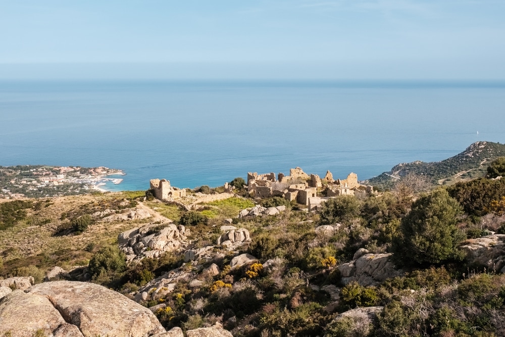
Photo Credit: Jon Ingall
- Hiking Distance – 3.4 miles
- Elevation gain – 392 meters
- Route Type – Loop
- Difficulty – Moderate
- Duration – 2.5 hours
This short loop walk starts in Lumio, Haute-Corse, and the clear trail is great for anyone looking for a moderate-difficulty hike with plenty to see. The best thing about this walk is that it runs through the abandoned village of Occi in Capu d’Occi.
Occi is located 377 meters above sea level and is steeped in history. It was inhabited in the 15th century but was deserted to escape the attacks of the Saracens. By the 18th century, the village was empty and is now one of the eeriest tourist destinations on the island of Corsica.
The hike then descends back into Lumio along a clear and easy path.
The trail is open year-round and is a great hiking destination anytime. Dogs are welcome on the trail, and it’s safe for them to be off-leash in some sections.
Lac De Melo
- Hiking Distance – 4 miles
- Elevation gain – 545 meters
- Route Type – Out and back
- Difficulty – Moderate
- Duration – 3 hours
This moderate out-and-back hike is near Corte, Haute-Corse, and typically takes around three hours to complete.
The drive here goes through Restonica valley and is spectacular in itself. The trail starts at the Bergeries de Grotelle, a paid parking lot.
The well-marked route takes walkers to the picture-perfect lakes of Melo and Capitello. This section is the only challenging part of the hike because there is a short climb up to the lakes. However, there are chains to assist you, and most fit and healthy people will have no problems with the walk.
Children who are used to walking are ok on this section of the hike, too. Walkers can take the same route back or the proposed variant, which is slightly more challenging but well-marked out.
The best times to tackle this beautiful walk are between May and October, when the climate is dry and sunny. However, the trail tends to get quite crowded during the high season, so it’s recommended to head out early in the morning. If you go during early spring, the lakes will likely be frozen, adding to their beauty.
Strada Vecia, Madonetta
- Hiking Distance – 5.9 miles
- Elevation gain – 284 meters
- Route Type – Loop
- Difficulty – Easy
- Duration – 3 hours
This hiking trail in Bonifacio, Corse-du-Sud, is an easy route that can be completed in three hours. For relatively minimal effort, hikers are awarded amazing views of the picturesque town and turquoise ocean below. It’s even possible to see Sardinia on clear days.
The walk heads to Strada Vecia, which is an old Genoese paved road lined with dry stone walls. Sights along the way include Madonetta Lighthouse, Fazzio Beach, and Plage de Paraguayan. This is an easy hike with no steep inclines or dangerous sections. Some side paths veer off to the cliff edges, but they aren’t dangerous if care is taken.
The trail is beautiful at any time of day, but completing it in the late afternoon is recommended, as the sunsets are breathtaking. Be warned that it’s a popular place for birding, running, and hiking, so it can get quite busy in the high season.
This trail is open year-round, and dogs are welcome, but they must be on a leash at all times. If you are staying in Bonifacio, you can walk to this central trail from your accommodation, making it extremely accessible for tourists in the area. If you plan to come by car, there is plenty of parking available in Bonifacio.
Mare a Mare Sud
- Hiking Distance – 52 miles
- Elevation gain – 3,557 meters
- Route Type – Thru-hike
- Difficulty – Moderate
- Duration – 5 days
This moderate multi-day hike is a spectacular five-day adventure through the Alta Rocca from one coast of the island to the other. Heading from Porto-Vecchio in the southeast to Propriano in the southwest, this walk gives visitors a glimpse into the diverse natural and cultural beauty of this rugged island.
Most of the trail is through scenic forests, and some time is spent in the maquis, a Mediterranean bushland ecosystem. Hikers will pass many remote mountain villages, and there are several streams that are ideal for a refreshing swim in the warmer months.
The trail is open all year, and with a maximum elevation of 1,171 meters, it’s passable even in the winter months. However, paths can get very muddy, so spring and fall are the best months to tackle the walk because there is less rain and more comfortable temperatures.
There are plenty of accommodation options along the route in the form of rest houses. It’s important to note that each rest house has a fixed capacity, and they can book up quickly, so plan ahead and reserve your space for each night of your walk in advance. Camping is also possible at rest house sites if preferred, and breakfast and dinner are offered at all of them.
Capo Rosso
- Hiking Distance – 4.3 miles
- Elevation gain – 457 meters
- Route Type – Loop
- Difficulty – Moderate
- Duration – 3 hours
The Capo Rosso hiking trail is a moderate walk with a well-marked path and some challenging inclines. Starting just west of Piana, it’s widely regarded as one of the most beautiful hikes on the island and is a wonderful way to spend an afternoon before heading back to Piana for dinner or a cold drink.
The walk goes by the Genoese Tughiu tower, which is one of the tallest in Corsica. The summit has incredible views of the Gulf of Porto, the Scandola Reserve, and the Gulf of Sagone and makes a great spot to catch your breath and have a snack. The path is easy to follow, and the tower is a great marker to orientate yourself with, as it’s visible for much of the trek.
The steep sections are mostly manageable, but the last section requires some scrambling. The trail does split into two sections at one point, and both are at the same difficulty level. However, the longer route takes you along the cliffs and offers some additional viewpoints.
This year-round trail is great in any season and at any time of day. The majority of the hiking trail is exposed though, so if you’re walking during the summer months, don’t forget your sunscreen and lots of water.
Calvi to Capu di a Veta
- Hiking Distance – 5.5 miles
- Elevation gain – 690 meters
- Route Type – Loop
- Difficulty – Easy
- Duration – 4 hours
This popular route offers an easy walk that is well-marked and full of fantastic views. The walk begins southwest of Calvi’s town center and heads up over the bay to deliver outstanding ocean views below.
The walk also passes the famous Notre Dame de la Serra and peaks at Capu di Veta, a 703-meter hill and the highest point above Calvi.
Most people will manage the hike in four hours or less; other than one or two tricky spots, it’s a very easy walk. The route is popular with families and hiking beginners, but more experienced trekkers shouldn’t discount this walk because the vistas really are incredible.
The walk is open year-round but can get slippery during the rainier months, so bear that in mind while planning your trip.
Girolata via Sentier du Facteur
- Hiking Distance – 6 miles
- Elevation gain – 555 meters
- Route Type – Out and back
- Difficulty – Easy
- Duration – 3.5 hours
The Girolata via Sentier du Facteur Hike is a well-known route named for Guy Ceccaldi, a postman who used to use this route to deliver mail to the tiny fishing village of Girolata. The town is one of the most picturesque villages on the island, with just 20 houses, and can only be reached by boat or by foot, which is a great reason to add this hike to your itinerary.
This simple walk starts at the Col du Croix, a mountain pass in Osani that connects Porto and Galeria. You can park your car here at the start of the trailhead, and the path is very well-marked, so it’s easy to navigate.
The first part of the walk heads into a stunning forest that opens out onto Plage de Tuara, a beautiful beach where you can stop for a swim on sunny days. The hike continues along an exposed balcony path until you reach Girolata.
Although this hiking route is relatively short, it’s recommended to allow yourself plenty of time to stop off and enjoy all the sights along the way. Aim to start out in the morning while the weather is cooler and work your way to Girolata for lunch at one of the lovely village restaurants before looping back to the parking lot.
This family-friendly walk can be done with children that are used to walking, and the trail is open year-round.
GR20
- Hiking Distance – 112 miles
- Elevation gain – 12,000 meters
- Route Type – Thru-hike
- Difficulty – Hard
- Duration – Between 7 and 16 days, depending on experience and side trips
The last entry on our list of the best hikes on Corsica, France, is GR20: a multi-day trek that is highly regarded in the hiking community throughout Europe. Up to 20,000 hikers tackle this challenging Corsican adventure each year, and with rugged terrain and hefty elevation gain, it’s recommended that only experienced walkers head out on the trail.
The trailheads are at Calenzana in the north and Conca in the south. There is no advantage of starting at one or the other, so it’s likely you’ll begin wherever best suits your travel itinerary. The path passes through wild hillsides and dramatic gorges, and the panoramic views across the island are unbeatable.
Despite the length and terrain of this challenging hike, it’s accessible to most fit and healthy people. The walk isn’t technical, and there are plenty of easy-to-follow signposts from start to finish. There are mountain huts (refuges) along the way should you encounter any issues or need to shelter from bad weather.
It’s possible to sleep overnight in these mountain huts, too, but you’ll need to book ahead and prepare to share the space with many other hikers. The alternative is to bring a tent and camp during the hike. Either way, bring a sleeping bag with you.
The time it takes to complete the trail largely depends on your walking speed and how many side trips you want to take. It’s possible to do the walk in five days if you’re fast, or it could take you close to three weeks if you plan to take it easy and explore Corsica’s many towns, villages, and beaches as you go.
The trail is open year-round, but it gets a good amount of snow during the late winter, so the only way to pass is with skis or snow shoes.
Hike and Stay in Corsica
So there you have it, those are the best hikes on Corsica, France. Whether you enjoy a short sunset stroll or are a hardy trekker looking for a challenge, this rugged, picture-perfect island destination has you covered.
Make sure you have your cameras ready: the vistas on these trekking routes are something you will want to capture forever.
Featured Image Credit: beboy